

Independence Pass, Colorado: Complete Driving Guide
Independence Pass, Colorado: Complete Driving Guide
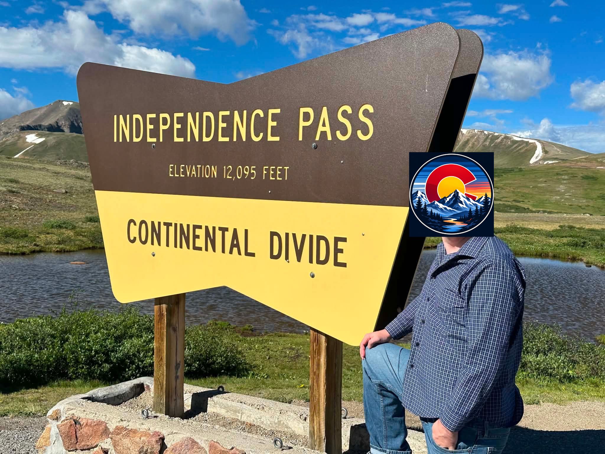
Cresting the Continental Divide at 12,095 feet, Independence Pass is the highest paved mountain pass in Colorado and one of the most dramatic drives in the state, connecting Aspen to Twin Lakes along a 32-mile stretch of Highway 82 through the Sawatch Range.
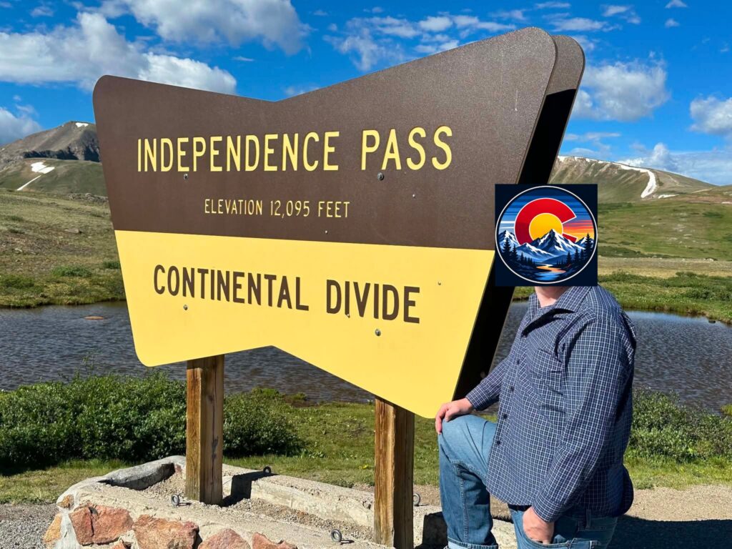
Elevation and Route
The summit sits 19 miles east of Aspen and 18 miles west of Twin Lakes, crossing through San Isabel National Forest on the eastern side and White River National Forest on the western side. The drive itself typically takes about 45 minutes point to point, though most visitors take considerably longer once they factor in photo stops, slower switchback driving, and simply taking in the alpine scenery.
Opening and Closing Dates
Independence Pass operates on a strict seasonal schedule due to heavy winter snowfall and avalanche risk on its steepest sections. The pass typically opens the week before Memorial Day weekend and closes in late October or early November, though exact dates shift year to year based on snowfall and weather conditions recent seasons have seen openings as late as May 21 and closures as early as late October. During the roughly seven-month winter closure, there is no way to cross the pass; all traffic between Aspen and the Front Range or Twin Lakes must detour via I-70 through Glenwood Canyon, adding significant time to the trip.
Vehicle Restrictions
Because of the pass’s tight curves, steep inclines, and narrow lanes, commercial vehicles and any vehicle-and-trailer combination exceeding 35 feet in combined length are strictly prohibited between mile point 47.2 near Aspen and mile point 84.2 near Twin Lakes. This restriction is enforced, not just recommended, so travelers with larger RVs or long trailers need to plan the Glenwood Canyon route instead, regardless of season.
What to See Along the Way
The Summit
The parking area at the top offers restrooms and short walking paths into alpine tundra, along with the “Independence Pass Continental Divide” sign that marks one of the most popular photo stops in the region. Snow can linger on nearby peaks well into summer, and weather at the summit changes quickly, so even a warm day at the base can turn cold and windy at 12,095 feet.
Twin Lakes
At the eastern base of the pass, the small historic community of Twin Lakes offers a good turnaround point or lunch stop, along with fishing access and views back up toward the pass itself.
Independence Ghost Town
Partway up the pass on the Aspen side sits the site of the old mining town of Independence, one of the higher-elevation ghost towns in Colorado, offering a glimpse of the mining history that first brought roads into this part of the Sawatch Range.
Road Cycling Independence Pass
The climb has become something of a bucket-list ride for road cyclists, particularly from the Aspen side, where riders face more than 4,000 feet of elevation gain over roughly 20 miles to the summit. It’s a serious undertaking rather than a casual ride, and cyclists should plan around the same afternoon thunderstorm risk that affects drivers.
Weather to Watch For
Summer afternoon thunderstorms are common and roll in with little warning, and because the summit sits well above treeline, there’s no shelter available if a storm develops while you’re at the top. Snow is possible at the summit in any month of the year, so checking current conditions before heading out even in July or August is worth the extra step.
Comparing Independence Pass to the Glenwood Canyon Route
While Independence Pass offers a shorter mileage route between the Front Range and Aspen when it’s open, the Glenwood Canyon route via I-70 is the only year-round option and adds roughly 40 miles to the trip. Drivers choosing between the two in season are generally trading a longer, faster interstate drive for a shorter but slower and more scenic mountain route.
Tips for Driving Independence Pass
- Check CDOT’s current status before heading out, since conditions and even open/closed status can change quickly, especially in shoulder-season months like May and October.
- Allow extra time. The posted 45-minute drive time assumes no stops, but nearly every overlook is worth pulling over for.
- Bring layers, even in summer, since temperatures at the summit run significantly colder than in Aspen or Twin Lakes.
- Confirm your vehicle length if towing a trailer or driving a larger RV, since the 35-foot combined-length restriction is strictly enforced.
Independence Pass delivers some of the most dramatic scenery reachable by paved road in Colorado, but its seasonal closure and vehicle restrictions mean it takes a bit more planning than a typical highway drive. Checking current conditions, building in time for stops, and packing for a much colder summit than the valleys below will make for a smoother trip over one of the state’s signature mountain passes.